|
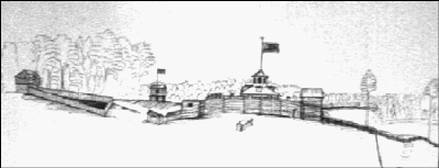
Fort Jefferson
"St. Clair had selected a site on a rather low, rounded gravel knoll, about five miles south of
modern-day Greenville, Ohio, for the location of his new fort of deposit. Although he said
that the site was ‘proper enough’ for a post, his men thought the location too
accessible to the enemy. It was surrounded by small knolls and was susceptible to have the
supply of water cut off because the fresh spring that issued nearby was about 100 feet
distant."
General St. Clair’s men built Fort Jefferson in October, 1791,
unaware that within a month it would be their refuge from a massive Indian army. Moving
north to the area of present day Ft. Recovery, St.
Clair’s army met a disastrous defeat against a superior Indian force. A gallant
attack on the Indian lines caused a breach that allowed the survivors to retreat the more
than 30 miles back to the safety of Fort Jefferson. Named for Thomas Jefferson, then
Secretary of State, the fort served as a supply base, and was abandoned in 1796.
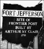
Located 4 miles south of present
day Greenville on State Route 121, the Ft. Jefferson park and monument marks the site of
the outpost. The monument is made of granite boulders, six feet square and twenty feet
tall. The area is maintained as a roadside park with a picnic shelter and grills. No part
of the fort remains but informational markers indicate where significant parts of the fort
once stood.
'Indian' segment written in December, 1997 by David Lodge
[ Back to Indians Index ]
|