Forty years before Interstate 75 slashed through the Shelby
County map, a far different road guide, using the written word rather than lines and
grids, pointed travelers to a more leisurely route through area towns and farmland. Modern
travelers, tracking Interstate 75’s exit numbers and Toledo or Dayton mileage
notations, hurry through the county in less than 18 minutes. But, followers of the early
guide used its point-to-point mileage readings matched with local churches, bridges,
cemeteries, schools, and other features to experience a "joy-ride with no troublesome
worries" through Shelby County and much of the Midwest. They were using the 1916
King’s Official Route Guide, published in Chicago for $1 a copy and self-described as
"...the most Accurate and Reliable Tour Book..."
Some landmarks common to county residents 80 years ago may confuse modern citizens. At
the 18-mile mark south of Wapakoneta, King’s Guide reads: "Pass road on left,
city limits of Mt. Auburn, go down grade." Two-tenths of a mile farther south,
travelers are advised: "...take left fork with trolley." That today could
get you arrested for going the wrong way on a one-way street in Sidney. Having just passed
the present-day Shelby County Motor Club and Lochard Hardware, you are headed off
Wapakoneta Avenue onto Main, rather than Ohio where you ought to be.
The ‘trolley’ refers
to the interurban — the Western Ohio Railway—serving the county until 1932.
"Sub-station power house on right" north of Anna along County Road 25-A and
"power house on left" south of Sidney’s Russell Road are surviving power
houses for the electric rail line. The Anna power station is a residence, while
Presser’s Auto Parts occupies the Sidney structure. Wentz’ car dealership once
used the building.
King’s Guide was published in eight
sections, covering Iowa to New York. Section 6—Ohio and Kentucky—contained 500
plus pages and featured advertising for auto tires ("Vacuum Cup Tires, warranty for
6,000 miles!), hotels, garages and other travel aids. Sidney’s Hotel Wagner was advertised with "60
rooms on the American Plan at $2, $2.50 and $3, Phone No. 52, E.W. Smith,
Proprietor." Fifth Third Bank now stands at Wagner’s West Poplar address.
Also advertised was Sidney’s Knupp Garage "Open day and night, special
attention to tourists, Opposite Fire Department." Two phone numbers are listed:
City phone 402 and Farmers 200, recalling the county’s early dual phone services. The fire department was in
the Monumental Building.
The guidebook touts King’s "Sign of Reliable Service...found displayed
only by reliable Hotels, garages, etc., where tourists will receive fair or better
accommodations and courteous service at regular rates." Publisher Sidney J.
King..."personally inspects all the hotels and garages." Mr. King also
inspected the routes, inserting road advisories: "road gravel" for the
Botkins to Sidney trip, but "road good gravel" for the Sidney to Piqua
journey.
Mr. King’s inspections did not always get things right. At mile 14.2, just south
of Franklin Township’s Pearl Cemetery,
current residents of Swanders might be surprised at this advice: "road on right
goes to Saunders." Or this instruction at mile 19.1, well into Sidney: "Cross
iron bridge over river." It was more likely the canal. Modern travelers streaking
at a 65-70 mph pace through the county on Interstate 75, could wonder at King’s
preface: "...we feel we have reached the pinnacle of perfection and although we
will strive to make each edition more perfect, yet in introducing this book to our
patrons, we think that it will adequately meet the demand of the public.
"Many guide instructions remain familiar, if too detailed, to modern
fast-moving area residents. For example, just south of Sidney, the guide notes: "0.7
— Avoid road on left which crosses bridge over river, keep right along river on left,
passing cemetery on right, go down grade, curve right."
Countians following those directions today would avoid the new jail and would be past
Graceland. Continuing on: "1.3 — Cross long iron bridge over river, pass road
on right, go up grade, curving left, going up grade." The river crossing was to
the west of the newer bypass bridge now carrying 25-A over the Miami. Southbound modern
tourists might marvel at how Botkins has grown. At 7.1 miles south of Wapak, 1916 tourists
were to "follow trolley through the hamlet of Botkins," a short stretch.
Botkins today extends another 2.5 miles south, crossing State Route 274 with the
corporation sign at the Ramsey-Sias plant. Landmarks vanished, or at least moved, over the
years. Mile mark 16.1: "Go through crossroads, pass church on right" describes the Plum Creek Methodist Church at the 25-A/Mason Road intersection. The church
building was moved into Sidney in the early 1940’s and now serves the Calvary United
Baptist Congregation at 514 Michigan Avenue. And, modern tourists might search vainly for
the town of Clinton: "17.1 — Go through crossroads (few scattered
houses)," an area now sandwiched by Hoewischer Road and the 25-A/I-75
interchange. Or, consider the aforementioned "city limits of Mt. Auburn," about
where the northtown Bank One branch stands.
Some of the brick schools, popular landmarks in the
road guide, survive. No trace remains of the school just north of the Anna traction line
power station, but the Finkenbine school at the guide’s 15.1 mile Wapak-Sidney mark
carries on with its varied career. Called the Blue Light Tavern in the 1940’s and
1950’s, the former school was later resurrected as a church, now the Northland
Missionary Baptist Church at 25-A/Port Jefferson Road (Sharp Road after 1980).
Another
school ("18.1 — Pass road and brick school house on right, power house on
left") was the Jimtown school, then outside the Sidney city limits. Parkwood Elementary replaced it in 1930 as
Sidney expanded. The brick school noted at a half mile from the Courthouse on South Main
was the First Ward school built in 1883, razed in 1949, and replaced by Lowell Elementary.
Redinbo school, south of Kirkwood Road, closed in 1929 and is now a residence. Rhodehamel
school, built in 1870, was replaced in 1929 by Orange Township school, now the Sidney
Missionary Church.
Sidney King did not trust motorists to find their way back home on their own. While
pages 114-116 plot the southbound course from Wapak to Piqua, pages 121-122 reverse the
route, all in the same detail. But, the northbound road advisory contradicts its
southbound counterpart noted earlier in this article: "Road all gravel"
describes the Piqua to Sidney route while "Road good gravel" took motorists on
to Wapak. Despite errors, the guide seemed to work for early county motorists. Swanders
resident J.E. Wyatt, signing his copy in 1919, recorded a successful 100-mile trip home
from Mansfield via Galion, Bucyrus, Upper Sandusky, Kenton, Waynesfield and Wapak.
Today’s readers can laboriously track Wyatt’s long-ago trip, using the
guide’s dual index of towns and point-to-point routes. But, Wyatt had more time for
that sort of thing in the leisurely days of pre-Interstate Highway ‘joyrides’.
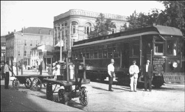
The Sidney trolley is
pictured in the photo above. Stops listed include Toledo,
Findlay, Lima, Piqua, Troy and
Dayton.
[ Back to Transportation Index ] |